Major discontinuities system of the Nepal Himalayan in engineering geology

                             Engineering Geology in Himalayas

Major Discontinuities system of the Nepal Himalaya and their Engineering Significance


  • Discontinuity simply is a plane or surface that marks a sharp change in physical and chemical characteristics in a soil or rock mass.

  • A discontinuity may be a bedding, schistosity, foliation, joint, fracture, cleavage, fissure or crack, or fault plane.

  • Discontinuity results in anisotropism and heterogeneity.


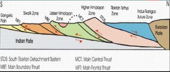
  • Major discontinuities system of Nepal is summarized as 4 tectonic zones: 

  • Indo-Gangetic Plain

  •  Siwalik or Sub Himalaya

  •  Lesser Himalaya

  • Higher Himalaya

  • Tethys Himalaya

These tectonic zones are separated from each other by different faults.


  • Main Frontal Thrust:


  • This is the southernmost thrust of Nepal Himalaya which separates the Terai plain from Siwalik zone. 

  • It is considered as the active thrust of Nepal Himalaya. 

  • This thrust zone is active for soil erosion, landslide, mass wasting and flash flood. 

  • The soil in this zone has less bearing capacity and cohesion. 

  • Debris flow is common in this zone. 


  • Main Boundary Thrust:


  • This thrust separates the Siwalik in south and the Lesser Himalaya in north. 

  • It is considered as the major source of earthquake.

  • Landslide type like debris slide, rock slide, and rock fall are very common in this thrust zone.

  • The rocks are very crumbled and sheared.


  • Main Central Thrust:


  • This thrust separates the Lesser Himalaya in South and Higher Himalaya in North.

  • It is a north dipping thrust.

  • This thrust zone is considered as a potential thrust for earthquake generation.

  • Geological structures like fold, fault are very common in this zone.

  • Rocks are easily breakable and jointed due to which landslides are common.


  • South Tibetan Detachment Fault :


  • South Tibetan Detachment System (STDS) is the boundary between the Higher Himalayan zone and the overlying sequence of the Tibetan- Tethys Himalayan zone. 

  • This is the normal fault of Nepal Himalaya. 

  • This zone is geologically very weak but tectonically very active. 

  • It consists of Indus-Tsangpo suture zone which is the contact between Indian plate and Tibetan plate in terms of tectonics.


Engineering Significance of Discontinuities


  • Discontinuities are weak in nature which reduces the bearing capacity.

  • Discontinuities in engineering site is vulnerable to various geological risks. So, if possible proper geological measures and engineering mitigation measures should be followed.

  • Discontinuities is sub-surface phenomenon. Therefore it greatly influences the groundwater table, groundwater motion, seismicity, volcanism and many more.


Major Engineering Geological Problems of Nepal Himalaya

Indo-Gangetic Plain (Terai)

Gangetic Plain that lies in Terai zone of Nepal extends from the Indian side in the South to the Sub-Himalayan (Siwalik) Zone to the North in Nepal.

Terai zone has nearly 1500 m thick alluvial sediments and is nearly 200 m above the sea level.

The alluvial sediments contain mainly boulder, gravel, silt and clay.


  • Due to the non-cohesive soil and low compaction, liquefaction is a common problem after earthquake.

  • While construction of large building in this zone, heavy sedimentation by flooding, and damming are major issues.

  • Major geological problems of Terai area;

  • A) Sediment deposition b) Flooding c) Cutting by river d) Earthquake e) Liquefaction f) Ground collapse.


  • Siwaliks: 


  • The Sub-Himalaya Zone which lies above Indo-Gangetic plane is also called as Siwalik Zone. Here we mainly find fluvial deposits.

  • This Zone extends all along the Himalaya forming the southernmost hill range with width of 8 to 50 km.

  • This zone consists of sedimentary rocks as mudstone, sandstone, shale and conglomerate.

  • The rocks in this zone are fragile, highly weathered, highly jointed and easily erodeable.

  • Major engineering Geological problems are: a) Soil erosion b) Landslide c) Toe erosion d) Floods e) Seepage f) Debris flow 


  • Lesser Himalaya:


  • The Lesser Himalayan rocks thrust southward over the rocks of Siwalik along the MBT. 

  • Main rock types of Siwalik are mudstone and sandstone and conglomerate. 

  • Generally two tectonic sequences namely autochthonous (geologically not moved mass) and allochthonous (geologically moved mass) can be distinguished in this zone throughout the Himalaya.

  • Major engineering geological problems of this zone are: a) Landslide (mainly slope failure and debris flow) b) Soil erosion c) Toe cutting by river d) Earthquake e) Rock fall and rock topple


  • Higher Himalaya:


The Higher Himalayan Zone mainly consists of huge pile of strongly metamorphosed rocks. 

This zone is separated with Tibetan-Tethys Zone by normal fault system called as South Tibetan Detachment System (STDS). 

It extents from east to west of the country and has different width in different places.

Major engineering geological problems of Higher Himalayan zone are: a) Rock fall b) GLOF c) Rock Avalanche d) Snow Avalanche e) Slope Failure


  • Tibetan Tethys zone: 


  • It lies in the northern part of the country close to Tibet border which is north of Higher Himalayan region.

  •  Here we mainly found Sedimentry rocks, such as shale, limestone, and sandstone.

  • Rocks that are found in Tibetan Tethys zones zones are also can be found in Famous mountains of Nepal like: Everest, Annapurna, Dhaulagiri etc.

  • Major engineering geological problems of this zone are: a) Rock avalanche b) Snow avalanche c) Scouring d) Slope Failure e) Landslide.


Importance of Engineering geological System in Nepalese Context


  • Engineering geological system consists of components like rock, soil, geological structures, hydrogeology, earthquake and seismicity which forms earth’s crust.

  • Nepal lies in tectonically active zone making it earthquake prone.

  • Knowledge in relation to engineering geological system gives information regarding geologic features of the terrain which further helps in planning, design and construction of engineering projects.


                                              Download other files:


Comments

Popular posts from this blog

Use of double mass curve analysis | Test for the consistency of records (Double mass curve)

Use of double mass curve analysis The double mass curve is used to check the consistency of many kinds of hydrological data by comparing data for a single station with that of pattern composed of the data from the several other station in the area. The double mass curve can be used to adjust inconsistent precipitation data. The theory of double mass curve is based upon the fact that a plot of the two cumulative quantities during the same period exhibit a straight line so long as the proportionality between the two remains unchanged and the slope of the line represent the proportionality. This method can be smooth at a time series and suppress random elements in the series. In recent 30 yrs, Chinese scholars analyzed the effects of soil and water conservation measures and land use/cover changes on runoff and sediments using double mass curve method and have achieved the good results. In this study, double-mass curves of precipitation vs sediments are plotted for the two contrastive peri...

Nikuradse experiment | variation of frictional factor (f) for laminar and turbulent flow

  Nikuradse', a German Engineer, He by gluing uniform sand grains on the inner side of the pipe wall to artifically roughened the pipe conducted a series of well- planned experiments on pipes. Here we choose the pipe of different diameter (D) and by changing the size of sand grain which gives (Roughness height= k), We can observe from his experiment that value of (k/D) varies from about "1/1014 to 1/30"  Since from dimensional analysis 'f is the function of Reynold's no VD/ ν  and ratio of 'k/D' Where, k =Average roughness height of pipe wall, D= Diameter of pipe,   ν = Kinematic viscosity of flowing fluid, Re =VD/ ν  = Reynold's no, k/D = Relative roughness.  Sometimes, "k/D" is also replaced by "R/k" Where, R= Radius of pipe and (R/k)= Relative smoothness whose value varies from "15 to 507''. Ad: Change(Variation) of friction factor for laminar flow (Re<2000) Head loss in laminar flow (i.e. Hagen-Poisseullie equati...

Hydrodynamically smooth and rough boundaries | Velocity distribution for turbulent flow

 Hydrodynamically smooth and rough boundaries Fig: Definition of smooth and rough boundaries In general, a boundary with irregularities of large average height 'K' on its surface is considered to  be a rough boundary and one with smaller 'K' value is considered as a smooth boundary. ✓ However, for a proper classification of smooth and rough boundaries, the flow and fluid characteristics are required to be considered in addition to the boundary characteristics. ✓ As the flow outside the laminar sub-layer is turbulent, eddies of various sizes are present which try  to penetrate through the laminar sublayer. But, due to greater thickness of laminar sub-layer ,   eddies can't reach the surface irregularities and thus the boundary acts as a smooth boundary. Such  a boundary is termed as " Hydro-dynamically Smooth Boundary" ✓ With the increase in Reynold's no (Re), the thickness of the laminar sub-layer  decreases and it's  can even become much smaller ...